Erosion, transport and deposition
- Geological Action of inland water: These are divided between surface water and groundwater. They can be: Streams, rivers, lakes and glaciers.
Streams: Streams are watercourses produced by snowmelt or rain, driven on a channel that doesn´t have a fixed course. The streams produce more erosion the softer the terrain or where vegetation is scarce. The erosive action of streams produces:
Streams: Streams are watercourses produced by snowmelt or rain, driven on a channel that doesn´t have a fixed course. The streams produce more erosion the softer the terrain or where vegetation is scarce. The erosive action of streams produces:
Gullies: They are V-shaped grooves formed by the erosion of streams in areas with very soft soil, such as clay, sand, etc.
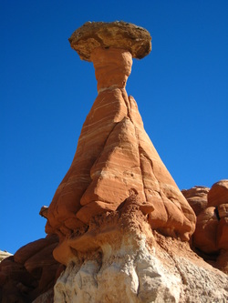
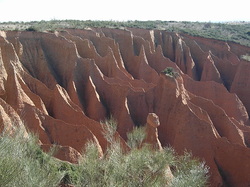
They are piramidal columnes crowned by a big rock wich evited the flow of thw soft material which were under it.
Lenar: They are grooves excavated in soluble rocks, such as limestone or gypsum, which are separated by columns that impede access to them.
Rivers are streams that run through a channel or fixed bed. The river is divided into three stretchs where erosion or sedimentation or transport predominate.
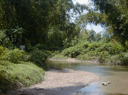
Upper course: In this stretch there are a great slope, so there is a big speed favoring water erosion, allowing the river locks into bed. In this stretch there are also transport, as were eroded materials are transported by the river to the other sections of the river.
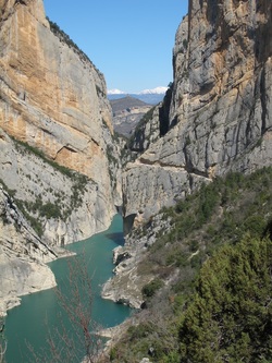
In this section, you can see throats gorge (photo), gorges and canyons.
In this section, you can see throats gorge (photo), gorges and canyons.
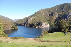
Middle course: In this stretch the slope is lower, so that transport is more dominant than erosion. Due to the lower power of the river, it makes meanders or curves to avoid the hardest materials so they can continue their journey. Along this stretch medium sized fragments that the river can no longer carry but can form boulders, are deposited in the banks and bottom forming alluvium.
Lower Course: Along this stretch there are hardly slope, so that prevent erosion and transport, which dominates sedimentation. In the final stretch, in the river mouth, the finer particles are deposited on both sides of the width of the bed form extensive fertile plains of ground, the plains.
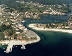
Depending on the characteristics of the coast where a river flows, there may be two types of mouth:
Deltas: Accumulation of sediment in a triangular shape formed when the river flows into a shallow area.
Estuary (photo): They are mouths open coasts with strong currents prevent sediments accumulate.
Deltas: Accumulation of sediment in a triangular shape formed when the river flows into a shallow area.
Estuary (photo): They are mouths open coasts with strong currents prevent sediments accumulate.
• Groundwater come from the ground infiltration of water from rain or snowmelt rivers. These waters within the earth are very slow and also the content of atmospheric gases causes the dissolution of rock materials. This water produces a peculiar modeling, karst.
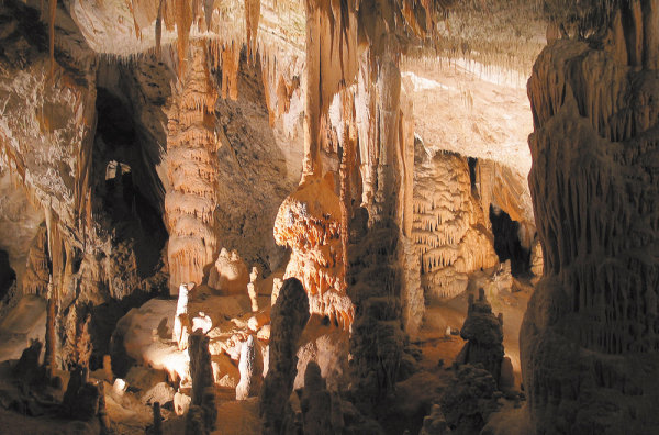
Rain water is infiltrated by gravity through the pores of the permeable rock, reaching the ground where accumulates into aquifers. This water can be extracted by drilling wells or arise naturally in a spring.
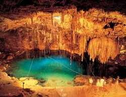
An aquifer is a permeable stratum or geological formation that allows the movement and storage of groundwater through their pores or cracks.
Glaciers are huge and deep masses of ice accumulated in regions with very low temperatures. Depending on your location we can find two types of glaciers:
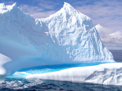
Polar ice cap glaciers: Those that are at the poles. They are formed by thick ice sheets covering large continental regions. The ice of the polar caps is displaced from its center towards the sea through numerous tongues. These break into large chunks of floating ice to reach the sea, forming icebergs.
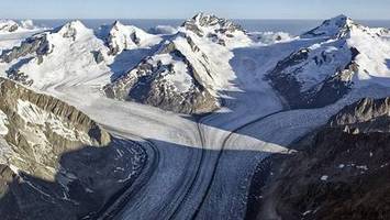
Alpine glaciers: Are glaciers that form in high mountain areas. In these glaciers differentiate three parts:
Cirque: The highest part of the glacier. This is a concave area where snowfall accumulates and becomes ice. If weather conditions change the ice is removed and forms a lake.
Glacier Valley: The channel that runs the ice or glacier tongue with a speed between 10 and 100 meters per year. The action of ice and moraines (rock fragments), dig the bottom and side walls of the valley, acquiring so its typical form "U"
Glacier Front: It is the lowest part of the glacier where the ice melts and gives rise to a stream or a river. In this part of the moraines are deposited.
- The geological action of marine waters: The sea is responsible for the modeling suffered by the coast, where the sea and the continents contact.
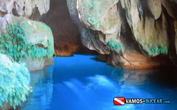
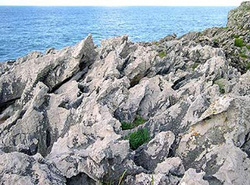
Sea Erosion: It is caused by the waves crash against the shore. Depending on various factors (such as the hardness of the rocks, the arrangement of the rocks or the existence of fractures or faults) becomes one or another coastal modeling. The forms of action characteristic of marine erosion are cliffs, abrasion platforms, natural arches, caves (photo), islets, coves, bays and inlets.
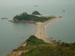
Transport and marine sedimentation: Materials uprooted during erosion and river brought are transported by waves and tides and deposited according to size in different areas of the coast. The larger fragments are deposited at the foot of the cliffs. The boulders, the gravel and sand are transported along the coast and are deposited along with shells forming beaches, coastal bars and tombolos (photo).
- Wind geological action: Wind is an air movement caused by the existence in the atmosphere of zones with different pressures. Air moves from areas of high pressure to areas of low pressure.
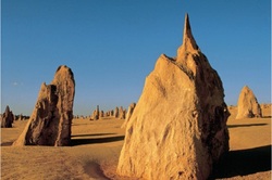
Wind erosion: wind, by itself, is a bit powerful erosive agent. However, its effect increases the lift and carry small particles that wear out and drilled by striking rocks.
Deflation: Rise of loose soil particles.
Corrosion: The weathering of rocks after the impact of small fragments driven by the wind.
Wind transport and sedimentation: Depending on the intensity of the air stream and the size of the particles, the wind can carry fragments by creep, saltation and suspension. In less intense, the fragments are released and form:
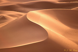
• Dunes (photo): Mounds in a variable shape caused to hit carried area against an obstacle that slows their progress. If the obstacle is very large, can not surpass the dune, dune so be still, and if it gets passed, will be mobile.
• Loess: are areas of deposition of fine particles carried by wind after being dragged for several kilometers.
• Loess: are areas of deposition of fine particles carried by wind after being dragged for several kilometers.
